Logistics, tech firms welcome deregulation of geo-spatial data
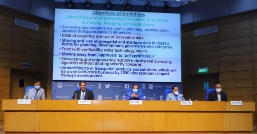
February 18, 2021: The government of India has liberalisation of geo-spatial data by which all such data produced using public funds, except classified geo-spatial data collected by security/law enforcement agencies, will be made accessible for scientific, economic and developmental purposes to all Indian entities and without any restrictions.

February 18, 2021: The government of India has liberalisation of geo-spatial data by which all such data produced using public funds, except classified geo-spatial data collected by security/law enforcement agencies, will be made accessible for scientific, economic and developmental purposes to all Indian entities and without any restrictions.
Giving details of the liberalised guidelines, the union minister for science & technology, earth sciences Dr Harsh Vardhan said that by liberalizing the geo-spatial guidelines, the government has taken a historic decision that will lead to a one lakh crore rupees geo-spatial economy.
The technology-based logistics companies were quick to welcome this move.
Shantanu Bhattacharrya, chief data scientist, Locus, said, “Innovation works best when it is only restricted by imagination. So far, innovation in the field of location intelligence has primarily focused on location-based data, but very few entities tightly control the underlying data itself or the actual mapping. Now, one can create better customization and quality, and also at a cheaper price.”
“The liberalisation of mapping is a game-changer, particularly for companies like Locus, specializing in creating advanced routing solutions. Now there will be far greater visibility on the country's fast-changing points of interest data and connectivity infrastructure. Also, the procurement or usage of such information can be a lot more straightforward. This initiative by the GoI would surely unleash the animal spirits in the location entrepreneurship space,” he added.
Dhruvil Sanghvi, CEO, LogiNext, said, “Throughout human history, we have observed that cartography has played a huge role in how power has shifted through various regions. Regions with defined mapping are able to enjoy a strategic advantage over other nations, which enables them to move forward in various areas of operations because of this visibility.”
“Within modern logistics, e-commerce and transportation industries, we are aggressively working to build a system that is defined by digital mapping, internet and mobility. Until now, not having access to geospatial data which was highly restricted hampered innovations within the sector. With the new policy changes, start-ups can now work on technologies and build systems which can be deployed among mainstream operations. This availability now makes it easier for us as well as other companies to utilise the information and drive innovative solutions for the country, to ultimately bolster economic growth. This opens up an entirely new segment for innovation and this is one step closer for the country, towards becoming an AtmaNirbhar Bharat,” he added.
Dr Harsh Vardhan said, “The next generation of technologies will use hyper-resolution maps. Availability of comprehensive, highly accurate, granular and constantly updated representation of geospatial data will significantly benefit diverse sectors of the economy and will significantly boost innovation in the country and greatly enhance the preparedness of the country for emergency response. The availability of data and modern mapping technologies to Indian companies is also crucial for achieving the vision of AtmaNirbharBharat and a five trillion-dollar economy”.
The minister highlighted, “With the advent of publicly available geospatial services, a lot of geospatial data that used to be in the restricted zone are freely and commonly available now and some of the policies/guidelines that used to regulate such information have been rendered obsolete and redundant”.
“What is readily available globally does not need to be regulated. For Indian entities, there would be complete deregulation with no prior approvals, security clearances, licenses, etc. for acquisition and production of geospatial data and geospatial data services including maps”, he declared.
Institutionalising ease of access of geospatial data will empower our domestic industries & surveying agencies.
— Dr Harsh Vardhan (@drharshvardhan) February 15, 2021
It'll help drive efficiencies in agriculture, enhance our emergency-response capabilities while also facilitating rise of new-age industries.@PMOIndia @IndiaDST pic.twitter.com/0WiV63IPBT


